Environmental Risks for US Native Lands (Drought, Heat, Rain, Wildfire: 1980-2020)
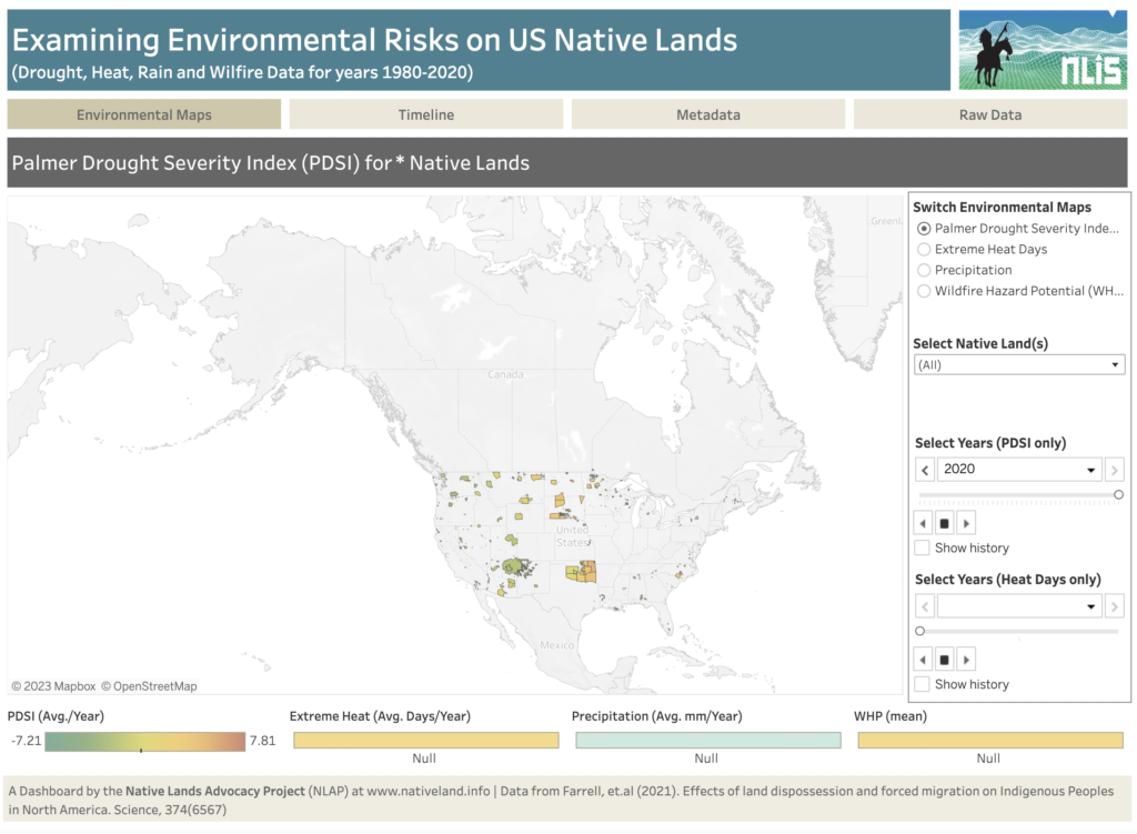
About this Dashboard This dashboard shows key environmental risks data for US tribal lands to help tribes monitor and assess risks and incorporate them in their land planning and decision-making. Data comes from the recent article: Farrell, J., Burow, P. B., McConnell, K., Bayham, J., Whyte, K., & Koss, G. (2021). Effects of land dispossession […]
Soil Organic Carbon for Land Planning on Native Lands
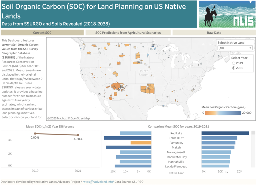
About this Dashboard This data dashboard summarizes past and present Soil Organic Carbon (SOC) data for all Native Lands but also future estimates depending on different agricultural scenarios. Data comes from the Soils Survey Geographic Database (SSURGO) for past and most to date available values (2019 and 2021). For future scenarios, we used estimates from […]
2023 Farm Bill: Native Farm Bill Coalition Priorities & How the NLIS Can Help
By Raven McMullin It goes without saying that the food system in the United States was created without the intent of maintaining or supporting traditional Native foodways. In fact, more than neglecting these traditional systems, new settlers sought to destroy Native food sources and economies—forcing dependence upon a strange and commodified food chain. However, traditional […]
New Demographic Features Added to NLAP’s Agriculture on Native Lands Data Dashboard
By Raven McMullin and Emma Scheerer Using our Agriculture on Native Lands Data Dashboard, you can now explore the age demographics of Native producers on Native lands! Through previous blog posts, story maps, and data dashboards, the Native Lands Advocacy Project (NLAP) has embarked on an extensive and critical analysis of the state of agriculture […]
US Drought Monitor (Google Earth Engine)
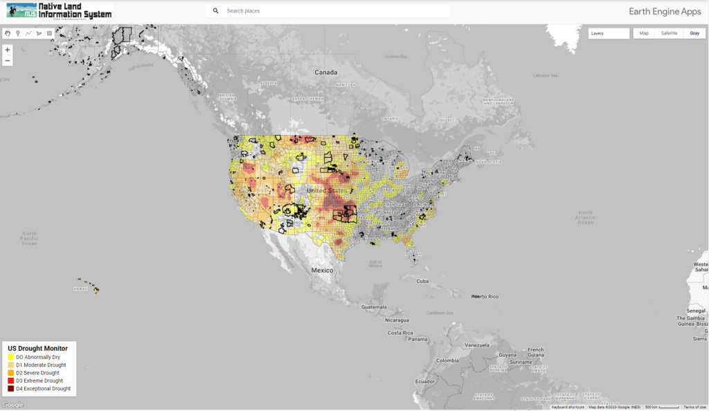
This map displays US Drought Conditions updated every Thursday as reported by National Drought Mitigation Center (NDMC)
The Legacy of Allotment on Contemporary Native Agriculture
In this storymap, we explore recent data from the USDA Census of Agriculture for American Indian Reservations to illustrate the devastating and intergenerational impacts of the Dawes Act. Although we trace current disparities back to their roots in oppressive agricultural policies, Native communities across the country have been leading efforts to change the narrative.
Ground Water on US Native Lands
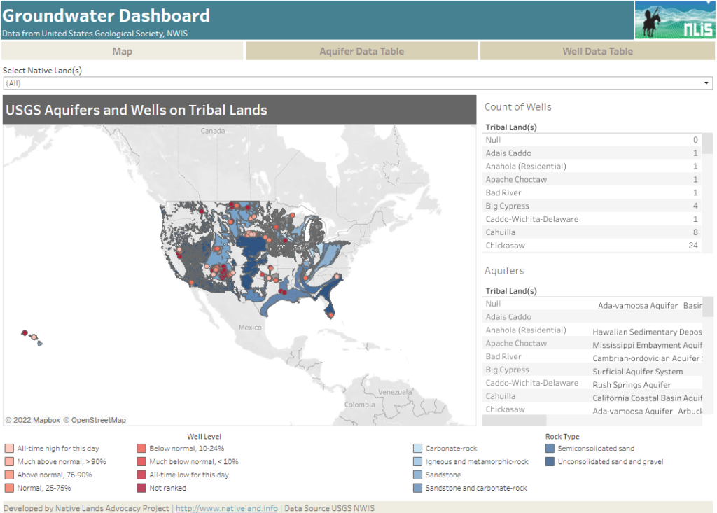
About this Dashboard This data dashboard summarizes data from the National Ground-Water Monitoring Network, and the national datasets of principle aquifers and aquifers of alluvial and glacial origin for Native Lands in the United States. This data shows underlying water resources and data monitoring the condition of wells on Native Lands. 0 Aquifer Types 0 […]
Surface Waters on Native Lands Dashboard
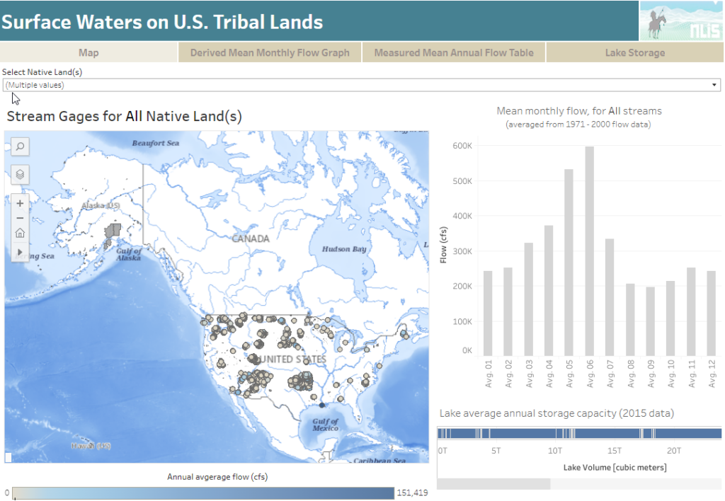
About this Dashboard This data includes the USGS’s National Hydrography Plus Dataset V2 (NHDPlus), released in 2012, and the 2021 TIGER Boundaries for U.S. American Tribal lands as of January 1st, 2021, as reported by the federally recognized tribal governments through the Census Bureau’s Boundary and Annexation Survey (BAS). Overlapping features and associated data from […]
RAP – Rangeland Analysis Platform
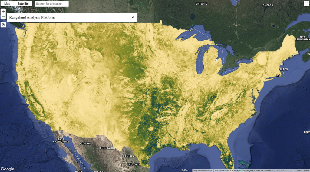
Fast, powerful, and free, the Rangeland Analysis Platform is an innovative online tool that quickly visualizes and analyzes vegetation data for the United States. Launch the app to examine trends at pasture, ranch, watershed, or broader scales. Datasets include:
Announcing New Updates to Our National Land Cover Database Dashboard!
By Raven McMullin // April 18, 2022 NLAP remains committed to making available to Tribes, Native organizations, and land caretakers the most relevant and current data critical for Native land planning and research. In furtherance of this commitment, we are excited to announce new updates to our National Land Cover Database Dashboard (NLCD) along with a […]
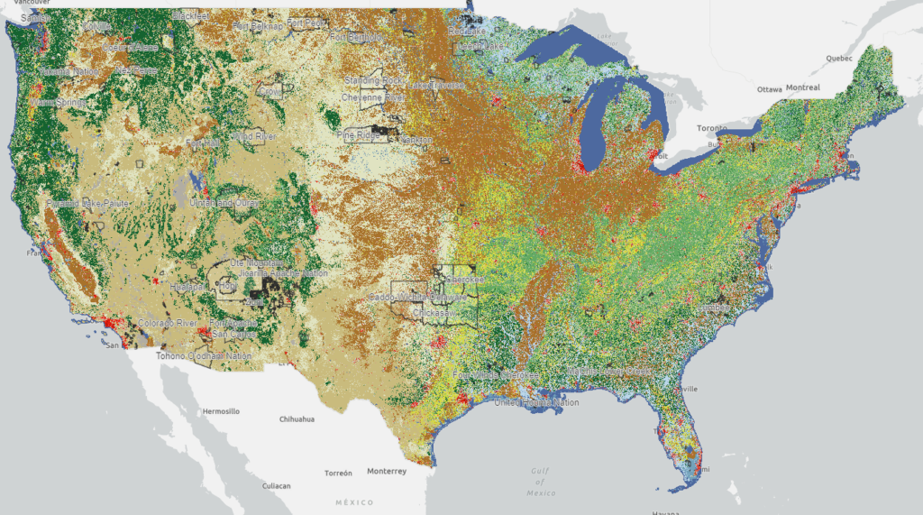
National Land Cover Database: Tribal Lands Viewer
This map viewer visualizes every available year of the National Land Cover Database (NLCD) and makes it possible to filter for 848 native land areas (reservations and off reservation trust lands) in the United States for 2001 and 2019.
RAP – Rangeland Production Explorer
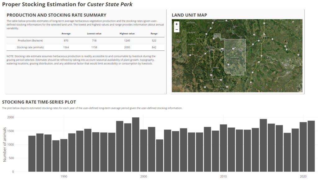
The RAP Production explorer enables you to compare current forage cover (updated every 16 days) for a specifc area (either drawn or using an uploaded boundary file) against 36 years of production.