Climate Data Portal for US Native Lands
Climate Data Portal for US Native Lands A toolkit to support sovereign climate planning on Native Lands This Climate Data Portal is thoughtfully designed to align with the non-linear, holistic approach tribes take when addressing climate adaptation. Drawing inspiration from the teachings of indigenous world views, which emphasize that the five basic needs of life—food, fire, […]
Introducing Our New Storymap: Good Fire: Mitigating Wildfire Risk & Healing Native Lands
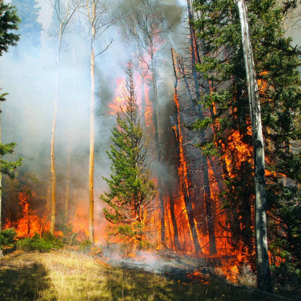
The Native Lands Advocacy Project is happy to announce our newest storymap: Good Fire: Mitigating Wildfire Risk & Healing Native Lands!
Good Fire: Mitigating Wildfire Risk & Healing Native Lands
After a long history of fire suppression in the United States, Native communities are reintroducing good fire to their lands.
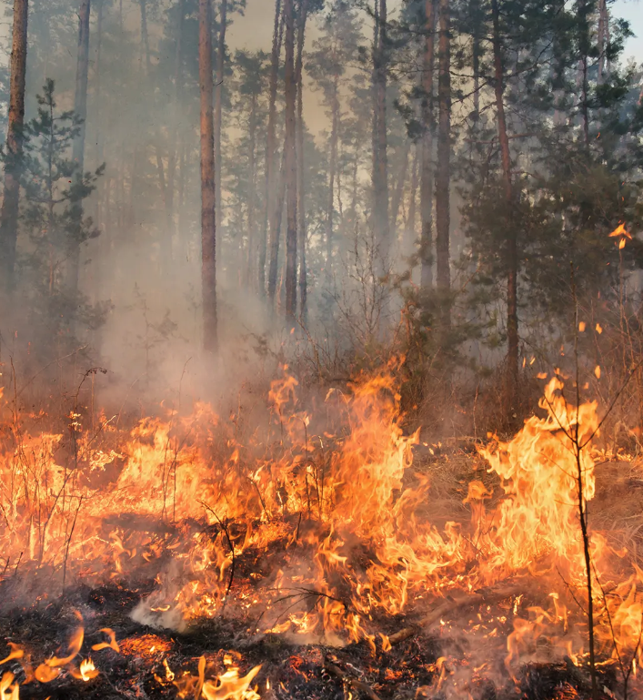
New Data Tools for Fire Stewardship on Native Lands
The Native Lands Advocacy Project (NLAP) is excited to highlight three data tools related to fire on U.S. Native lands. These three tools (our Thermal Activity Map, Environmental Risks Dashboard, and Extent of Fires on US Native Lands Dashboard) can help users understand the factors contributing to wildfires and their impact on Native Nations. These […]
Precipitation Projections and Winter Trends on US Native Lands
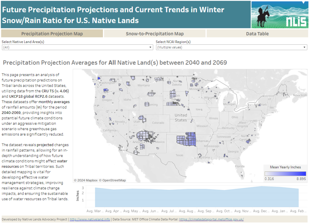
About this Dashboard This data dashboard summarizes data from future precipitation predictions and historical changes in the snow-to-precipitation ratio on Tribal lands in the contiguous United States. The precipitation predictions are based on datasets from the CRU TS (v. 4.06) and UKCP18 global RCP2.6 scenarios, while the snow-to-precipitation ratio data comes from 177 weather stations […]
Soil Salinity in U.S. Native Lands
This map displays soil salinity data layers derived from the Harmonized World Soil Database (HWSD) Global Soil Quality – Constraints due to Excess Salts (HWSD Excess Salts). This Soil Salinity data on US Native Lands is presented here as a potential resource for Tribes to use in natural resource and climate adaptation assessment and planning.
Change in Rain & Snow Patterns on U.S. Native Lands
This map displays data layers based on the EPA’s Climate Change Indicators in the United States report, specifically focusing on Change in Rain & Snow Patterns on U.S. Native lands. On this map, view layers related to change in snowfall, precipitation, snow-to-precipitation ratio, and April snowpack in western US.
Temperature Change Patterns on U.S. Native Lands
This map displays data layers based on the EPA’s Climate Change Indicators in the United States report, specifically focusing on Temperature Change Patterns on U.S. Native lands. On this map, view layers related to annual average air temperatures, unusually hot temperatures, and unusually low temperatures.
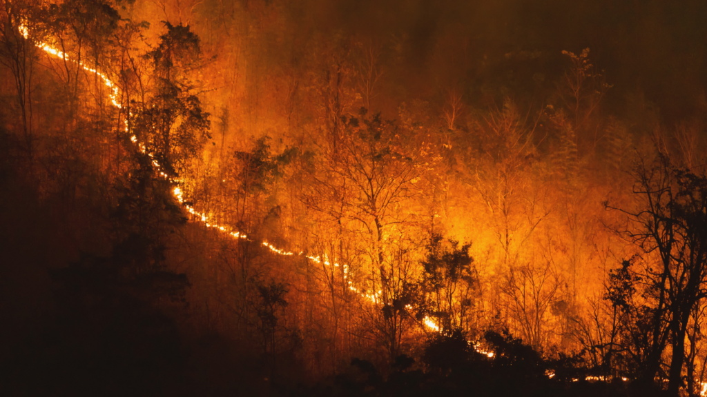
Extent of Fires on US Native Lands
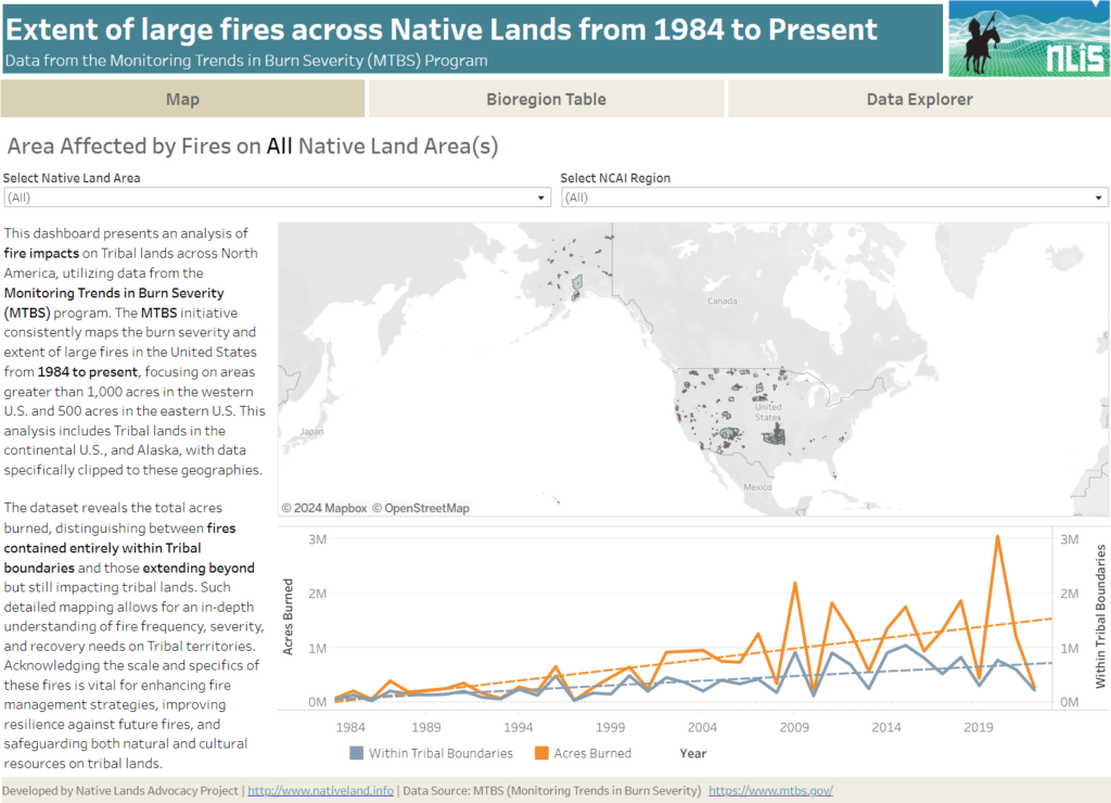
About this Dashboard This data dashboard summarizes data from the Monitoring Trends in Burn Severity (MTBS) Dataset, which the USGS EROS and the United States Department of Agriculture Forest Service jointly implemented. It highlights the distribution and impact of wildfires on Native lands between 1984 and 2022. The dashboard features detailed maps and interactive elements, allowing users […]
Renewable Energy Production on US Native Lands
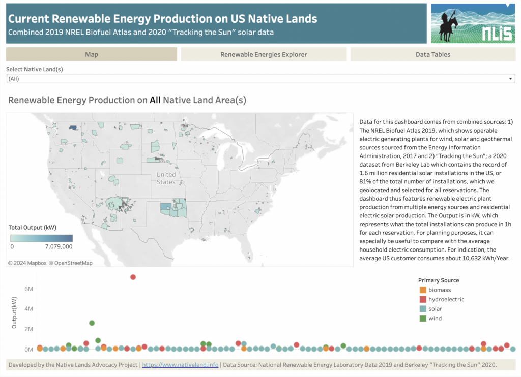
About this Dashboard This dashboard features current renewable energy production (wind, solar, biomass, and hydroelectric) on US Native Lands. It combines data from two sources: (1) the NREL Biofuel Atlas 2019, which shows operable electric generating plants for wind, solar, and geothermal sources sourced from the Energy Information Administration (2017), and (2) “Tracking the Sun,” a […]
Crop Diversity on US Native Lands
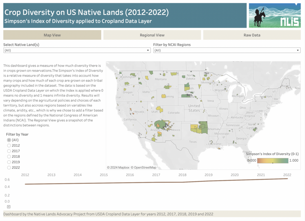
About this Dashboard The Crop Diversity Dashboard is an estimate of the relative diversity of crops grown on tribal lands. We use the Simpson’s Index of Diversity to estimate crop diversity from both the variety of crops grown and their respective acres within each reservation, with 0 meaning no crop diversity and 1 meaning infinite […]
Species Richness on US Native Lands
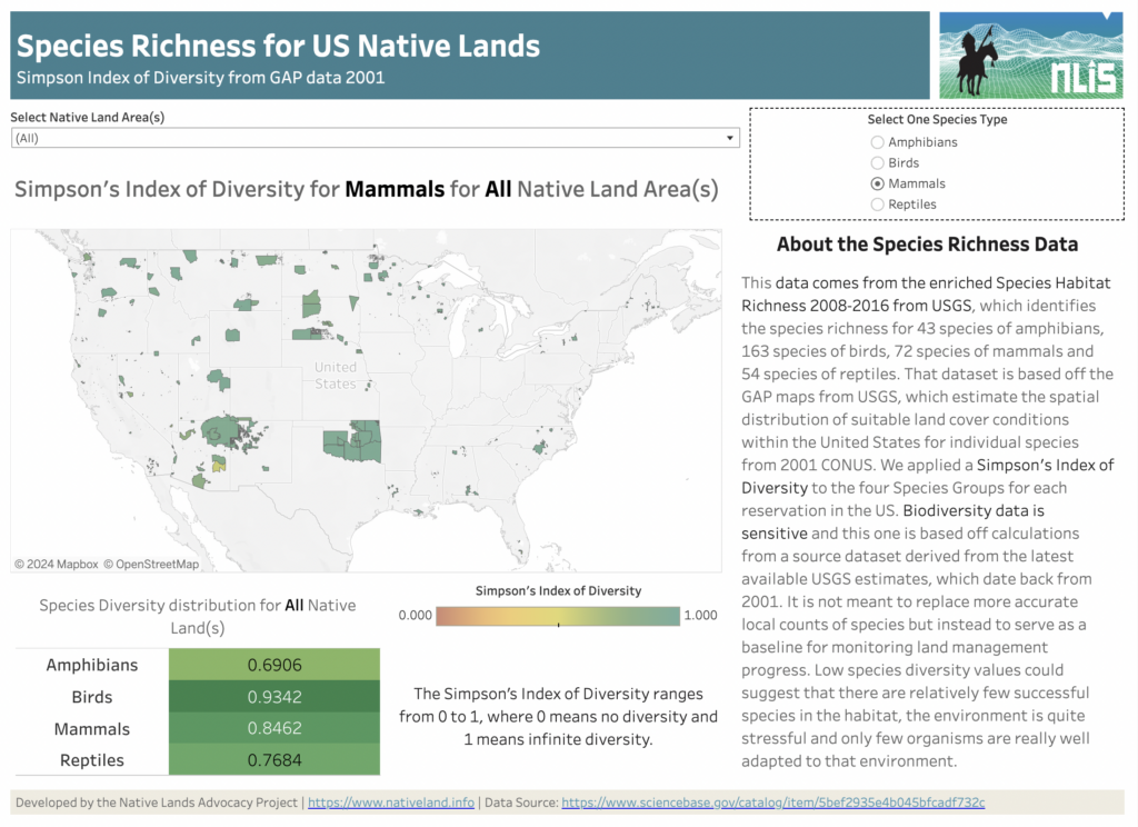
About this Dashboard Water Stress Categories 0 Native Land Areas 0 Datasets utilized 0 Possible Visualizations 0 About the Data This data comes from the Species Habitat Richness 2008-2016 from USGS, which identifies the species richness for 43 species of amphibians, 163 species of birds, 72 species of mammals, and 54 species of reptiles. This […]