In addition to maintaining the NLIS as a living repository of public data for Tribal decision-making, the Native Lands Advocacy Project provides private, customized support to Tribal Nations, organizations, and citizens. This page highlights the range of our consulting work. Because each consultee’s needs are unique, we encourage you to reach out to us directly so we can together explore how NLAP can help you.
Consulting Services of the Native Lands Advocacy Project
While the Native Lands Advocacy Project (NLAP) was founded in 2019, our team has over 20 years of experience working in Indian Country on Native land tenure, agriculture, climate, and other mapping issues. Every partnership we form begins with questions that arise from the grassroots level. For example:
Is it feasible for my tribe to introduce a buffalo herd to our lands?
We have issues with invasive species. Can you help us map them out?
My tribe wants to create an Agriculture and/or Integrated Resource Management plan, but where do we start?
Your data platform seems great, but overwhelming. How can I leverage it for my tribe’s decision-making?
In our tribe, we want to build our own data system. Can you help?
NLAP understands that good data is a cornerstone of Tribal Sovereignty and that tribes need access to quality, relevant information to make decisions. That’s why we create custom data packages, decision-support tools, reports, and analyses to help Tribal Nations, organizations, and citizens answer these critical questions.
Our approach is grassroots-up rather than top-down. Because of this, our commitments to Indian Country include keeping our costs for these services low, especially compared to other GIS firms, and upholding Tribal data sovereignty. At the heart of each consultation is relationship- and trust-building as we seek to grow our ecosystem of partners for the betterment of Indian Country.
Contact us by using the button above or by emailing info@nativeland.info. Read on for more specifics about how NLAP can support you.
Core Competencies of NLAP: Consulting for Indigenous Data, Land, and Food Systems
We help Indigenous Nations, nonprofits, and research partners transform data into tools for land stewardship, food sovereignty, and sustainable futures. Our work blends advanced GIS and data science with community-driven research and Indigenous knowledge systems. Learn more about our core competencies, including examples of our work, below!
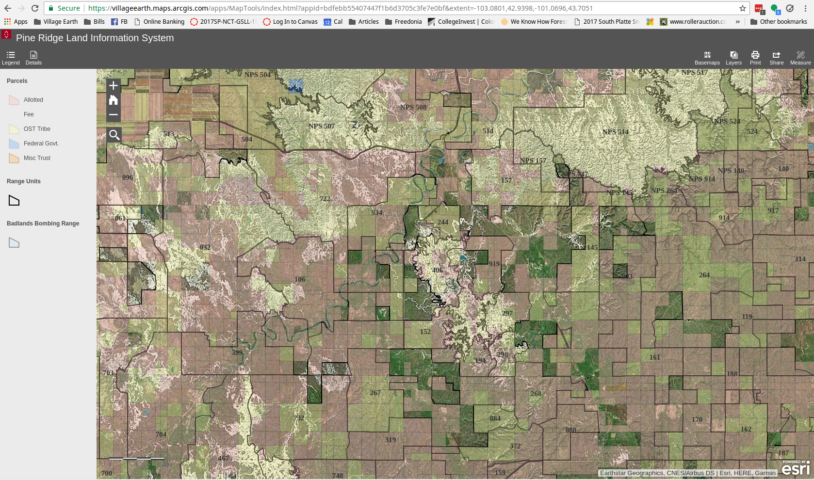
Land and Resource Information Systems
We build custom GIS platforms that help Tribal Nations and organizations manage land ownership, resources, and environmental change.
Services include: geodatabase development, interactive mapping tools, and technical design for land information systems.
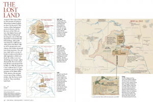
For example, see: The Pine Ridge Land Information System, a model for strategic Nation-level land governance, developed in partnership with the Oglala Sioux Tribe’s Land Office and the Indian Land Tenure Foundation.
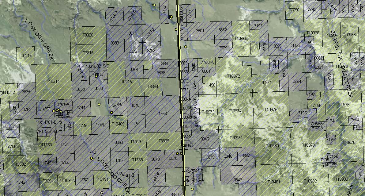
Maps tell stories that data alone cannot. NLAP turns complex datasets into intuitive, interactive storymaps and atlases that inform planning, policy, and outreach.
Services include:storymapping, map book publication, and interactive web mapping.
For example, see: The Pine Ridge Strategic Land Planning Map Book, one of NLAP’s earliest projects for Native land tenure. For more recent examples of how GIS technology has enhanced this work, see the Treaty Signers Database, a relational mapping tool NLAP developed for the Indian Land Tenure Foundation, and the Environmental Risk dashboard NLAP created for our academic partners.
NLAP combines historical records, geospatial data, and statistical analysis to support research and policy development on Indigenous land, food, and sovereignty.
Services include: historical land tenure analysis, feasibility studies, data synthesis, and reporting.
For example, see: Historic land studies and national reports informing tribal policy and advocacy, such as the Historic Loss Assessment for the People of the Sacred Land.
Sovereign food systems depend on good data. We collaborate with Tribal Nations, agricultural organizations, and food hubs to evaluate production systems, model land use, and visualize agricultural change.
Services include: data collection and dashboard creation, spatial analysis of food systems, and climate-smart agriculture mapping.
For example: NLAP has produced pasture analyses, buffalo feasibility studies, food hub feasibility studies, and agricultural carrying capacity assessments. These outputs are typically private. Please contact us if you’d like to learn more!
We help partners gain the skills and confidence to manage their own data, build their own maps, and advocate with evidence.
Services include: GIS, data literacy, and environmental data training; guidance on how to use our open access platform, the Native Land Information System
For example: NLAP has conducted virtual and hands-on GIS training and data workshops for environmental and agricultural professionals, tribal colleges, etc.
Tribal Nations require reliable and up-to-date data to support their decision-making as they respond to the impacts of climate change on their lands. NLAP develops climate-related data tools and resources that support ecological protection and cultural continuity.
Services include: habitat assessment, forestry mapping, water resource visualization, etc.
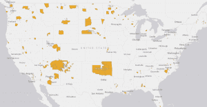
For example: NLAP has worked with tribes to monitor invasive species, assess changes in ideal habitats for culturally significant species, and more, but these outputs are typically private. For a public example of our climate-related work, see the Climate Data Portal for U.S. Native Lands.
We partner with universities, think tanks, and NGOs to co-develop research projects at the intersection of Indigenous knowledge and technical data analysis.
Services include: project design, data processing, visualization, and publication support.
Whether your project involves mapping, data building, or applied research, we specialize in turning complex information into clear, community-centered solutions. Get in touch to discuss how we can collaborate on your next project!