Key Findings from NLAP’s Literature Review of Tribal Climate Adaptation Plans

What climate concerns do tribes across the United States share? How do these climate concerns vary by region? Our Tribal Climate Literature Review identifies preliminary answers to these questions and provides insights to empower tribal climate planning.
FSA Spending Dashboard: Insights from 2021 & 2023 Across Native and Non-Native Lands

About this Dashboard This interactive dashboard provides a detailed analysis of USDA Farm Service Agency (FSA) program disbursements for 2021 and 2023, offering insights into federal spending on agricultural programs across the United States. The dashboard includes data for all FSA program recipients, providing a comprehensive view of how funds were allocated during these years […]
Introducing the Climate Data Portal for U.S. Native Lands

The Native Lands Advocacy Project (NLAP) is thrilled to announce the launch of our Climate Data Portal for U.S. Native Lands! Developed with funding from the Native American Agriculture Fund, this portal is the result of our dedicated GIS team’s efforts to create & consolidate relevant climate-related data tools into one living resource. NLAP acknowledges […]
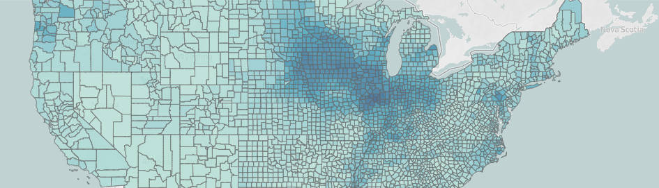
Average Wind Speed on US Native Lands
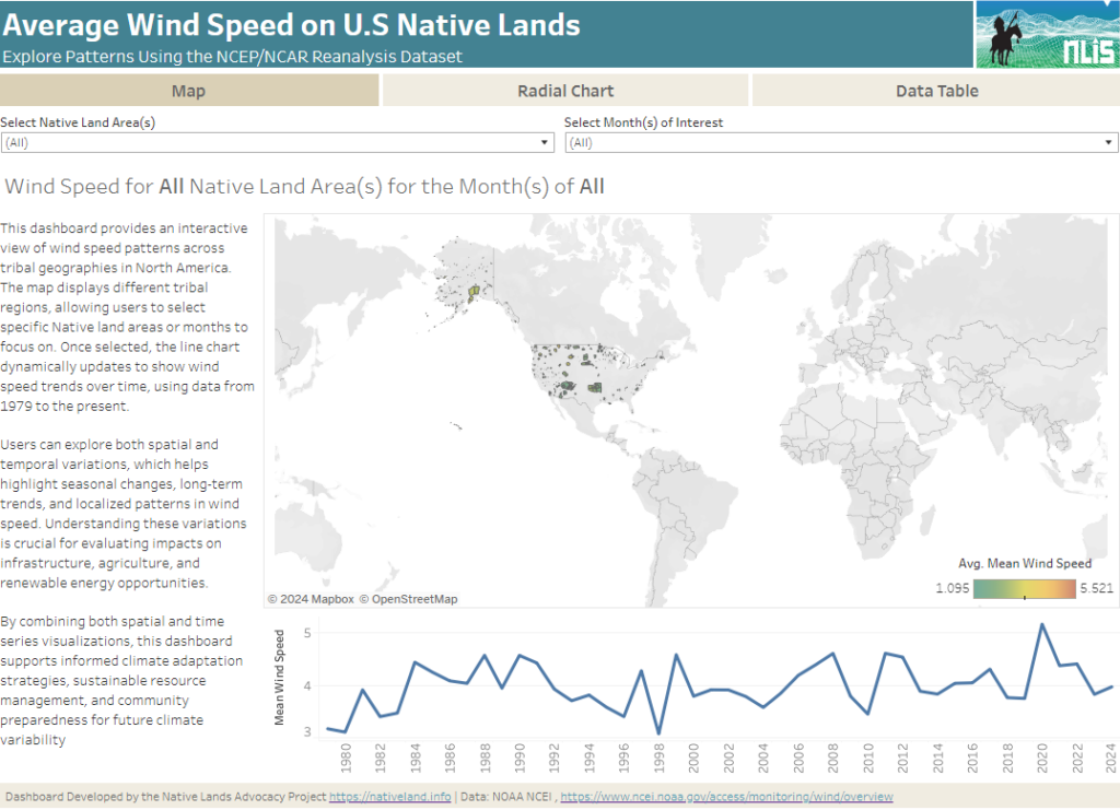
About this Dashboard This interactive dashboard provides a comprehensive analysis of average wind speed patterns across tribal lands in North America, using data from the NCEP/NCAR Reanalysis dataset. The dashboard allows users to explore wind speed trends by selecting specific Native land areas and years, or by viewing aggregated data across all regions and years. […]
Precipitation Projections and Winter Trends on US Native Lands
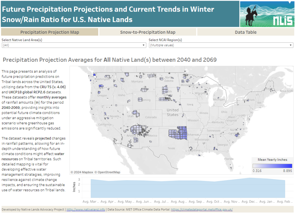
About this Dashboard This data dashboard summarizes data from future precipitation predictions and historical changes in the snow-to-precipitation ratio on Tribal lands in the contiguous United States. The precipitation predictions are based on datasets from the CRU TS (v. 4.06) and UKCP18 global RCP2.6 scenarios, while the snow-to-precipitation ratio data comes from 177 weather stations […]
Extent of Fires on US Native Lands
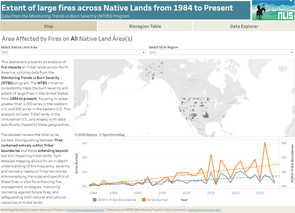
About this Dashboard This data dashboard summarizes data from the Monitoring Trends in Burn Severity (MTBS) Dataset, which the USGS EROS and the United States Department of Agriculture Forest Service jointly implemented. It highlights the distribution and impact of wildfires on Native lands between 1984 and 2022. The dashboard features detailed maps and interactive elements, allowing users […]
Renewable Energy Production on US Native Lands
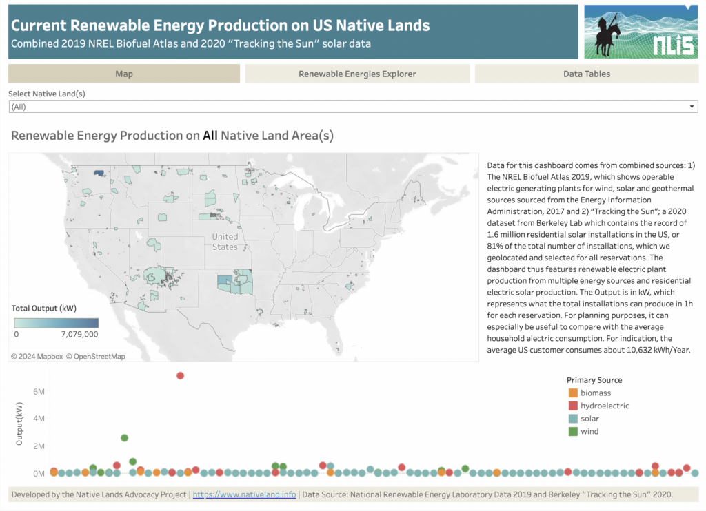
About this Dashboard This dashboard features current renewable energy production (wind, solar, biomass, and hydroelectric) on US Native Lands. It combines data from two sources: (1) the NREL Biofuel Atlas 2019, which shows operable electric generating plants for wind, solar, and geothermal sources sourced from the Energy Information Administration (2017), and (2) “Tracking the Sun,” a […]
Crop Diversity on US Native Lands
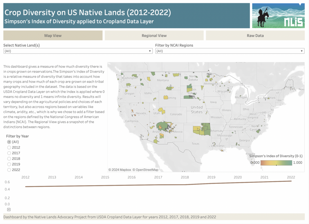
About this Dashboard The Crop Diversity Dashboard is an estimate of the relative diversity of crops grown on tribal lands. We use the Simpson’s Index of Diversity to estimate crop diversity from both the variety of crops grown and their respective acres within each reservation, with 0 meaning no crop diversity and 1 meaning infinite […]
Species Richness on US Native Lands
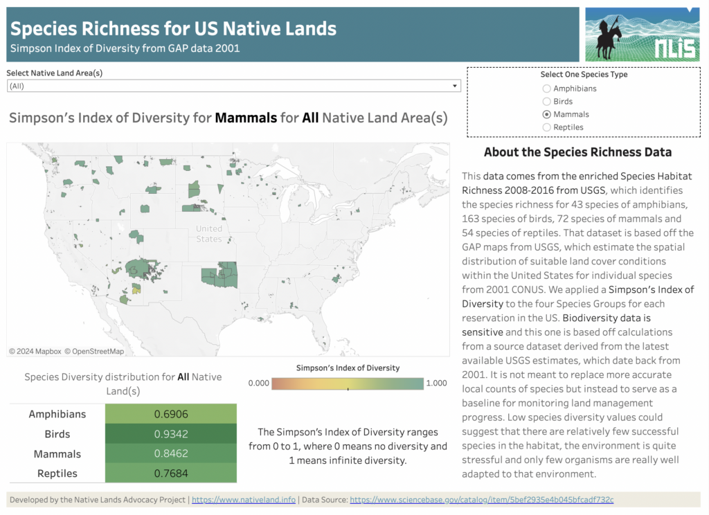
About this Dashboard Water Stress Categories 0 Native Land Areas 0 Datasets utilized 0 Possible Visualizations 0 About the Data This data comes from the Species Habitat Richness 2008-2016 from USGS, which identifies the species richness for 43 species of amphibians, 163 species of birds, 72 species of mammals, and 54 species of reptiles. This […]
Agricultural Water Stress on US Native Lands
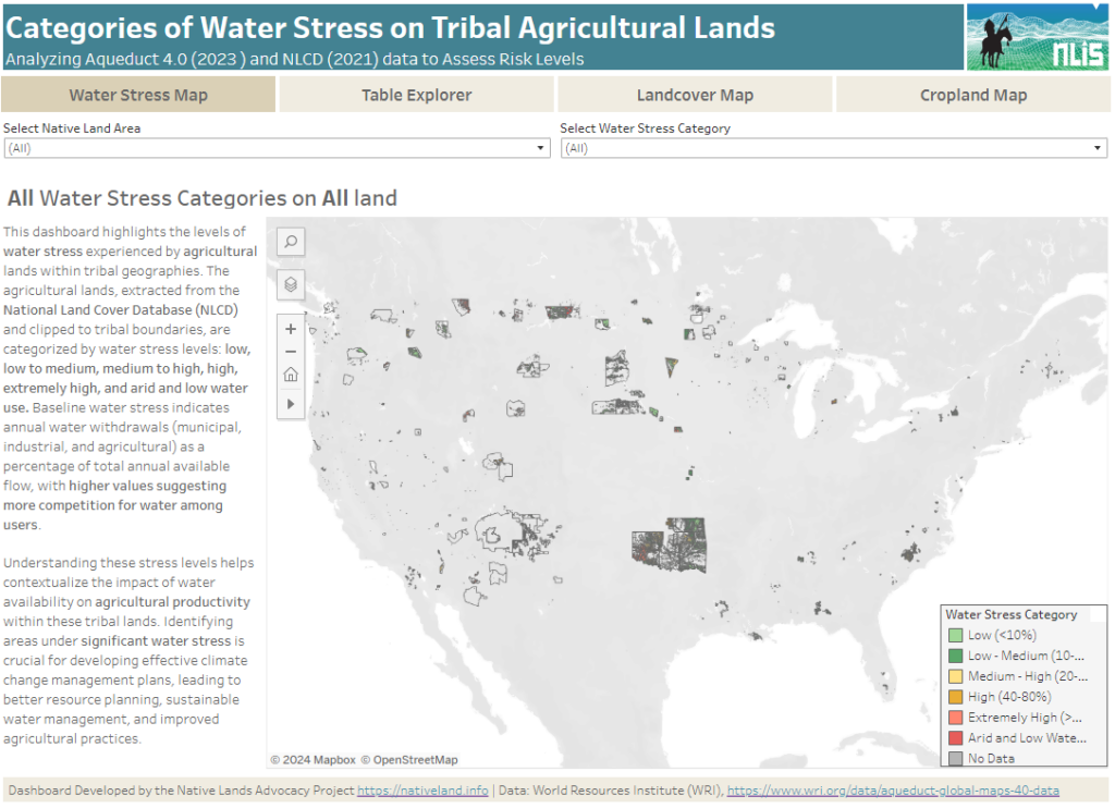
About this Dashboard This data dashboard summarizes data from the World Resources Institute, and the National Land Cover Database for Native Lands in the United States. It highlights the distribution and impact of water stress on agricultural lands within Native boundaries. The dashboard features detailed maps and interactive elements, allowing users to explore different water […]
Reservation Croplands: How Native Farmers and Ranchers Can Leverage the USDA’s Cropland Data Layer for Land Planning
In 2022, there were about 110 million acres of cropland (5.7%) on Native American reservations (including on-reservation and off-reservation trust lands). What are these croplands and land covers? How have they changed over time? Why does this data matter?
Introducing New Resource Tools for Grassland Protection and Restoration
NLAP is happy to announce two new resource tools for grassland and biodiversity protection: our storymap, Grasslands: The Land and the People that Call it Home, and our Conservation Reserve Program Dashboard!