How To use this Thematic Map
This map displays the boundaries of U.S. tribal lands. When you click on one of these boundaries, the application will generate a time series chart showing the drought status of that specific area from the year 2000 to the present. Please note that the time it takes for the chart to display may vary depending on the size of the tribal region, and it could take up to a minute for larger areas. Your patience is appreciated during this process. The generated chart provides a detailed historical view of drought conditions, helping users understand long-term trends and current drought statuses within tribal lands.
About the US Drought Monitor Thematic Map
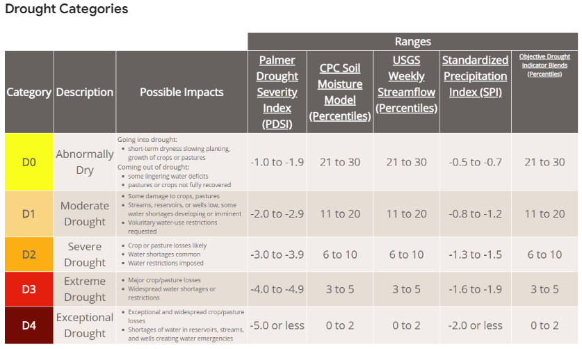
This map displays U.S. Drought Conditions updated every Thursday by the National Drought Mitigation Center (NDMC) at the University of Nebraska-Lincoln, processed on Google Earth Engine by: Samapriya Roy. The U.S. Drought Monitor, a collaborative effort since 1999 among the NDMC, NOAA, and USDA, is created by meteorologists and climatologists who take turns interpreting data from precipitation, streamflow, reservoir levels, temperature, soil moisture, and vegetation health, combined with local insights from over 450 experts. This convergence of evidence approach ensures a comprehensive view of drought conditions, updated weekly based on the latest data.
The Drought Monitor informs USDA disaster declarations and program eligibility, guiding state, local, and tribal drought responses. Drought, a slow-moving but impactful hazard, affects agriculture, water supply, energy production, public health, and wildlife, and contributes to wildfires, causing significant economic losses. While large urban water systems often manage to maintain supply during dry periods, drought still poses severe risks comparable to other natural disasters. Learn more about the U.S. Drought Monitor and its methodology on the Drought Classification page.