About This Map
This map displays soil salinity data layers derived from the Harmonized World Soil Database (HWSD) Global Soil Quality – Constraints due to Excess Salts (HWSD Excess Salts), established in July 2008. This comprehensive database is accessible through the Data Basin website and is available as a raster file on ArcGIS Online. Users with an active ArcGIS Online license can export and download these layers for further analysis.
About the Soil Salinity Dataset
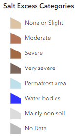
The HWSD Excess Salts dataset characterizes soil salinity, identifying seven categories of salt constraints. Soil salinity, caused by the accumulation of salts in the soil, significantly impacts agricultural productivity. It inhibits water uptake by crops, with moderate salinity reducing growth and yields, and high salinity levels potentially killing crops.
Soil salinity is measured as Electric Conductivity (EC in dS/m) or as saturation of the exchange complex with sodium ions, referred to as sodicity or sodium alkalinity, and is measured as Exchangeable Sodium Percentage (ESP). Presented soil qualities have been estimated for the sequence 1 soils in each grid cell with maize as the reference crop. The derived maps for the individual soil qualities represent the qualities of the main soils only.
For any site of interest, simply click on the area and you will receive acreages for different soil salinity categories for that area, along with a pie chart that shows the percentage of coverage for each soil salinity category.
This Soil Salinity data on US Native Lands is presented here as a potential resource for Tribes to use in natural resource and climate adaptation assessment and planning. For more resources related to tribal climate & agricultural planning, explore NLAP’s other data dashboards and maps.
About the Data Source
The HWSD Global Soil Quality database was developed in partnership with:
- ISRIC-World Soil Information and the Food and Agriculture Organization of the United Nations (FAO), responsible for developing regional soil and terrain databases and the WISE soil profile database;
- The European Soil Bureau Network, which recently completed a major update of soil information for Europe and northern Eurasia, and
- The Institute of Soil Science, Chinese Academy of Sciences, which provided the recent 1:1,000,000 scale Soil Map of China.
The harmonization and data entry in a GIS were assured at the International Institute for Applied System Analysis (IIASA), and the verification of the database was undertaken by all partners. This product aims to be of practical use to modelers and serves prospective studies in agro-ecological zoning, food security, and climate change impacts, among others. A resolution of about 1 km (30 arc seconds by 30 arc seconds) was selected.