Food-System Transition Index
The Food-System Transition Index for US Native Land is a first of a kind tool specifically designed for Native Land which compiles 20 key indicators to measure the transition to healthy food-systems. Here, you will find a baseline measure connecting different aspects of food-systems such as agricultural land use, land sovereignty, healthy food access and the climate impact of food production to support tribal sustainable land use planning. The Index is an innovative measure that challenges colonized datasets to tell a different story.
"Food is a connection to our past, to our people, to our lands that ensures we as Indigenous people exist and continue to exist"
A-dae Romero-Briones, First Nations Development Institute
FSTI: What is it for?
The FSTI IS an exploratory aggregated measure meant to support native land planning by providing baseline information about the health of native food-systems and their transition towards sustainable and sovereign food production and land management practices. It is an ongoing research effort that is meant to evolve and change from users feedbacks and needs.
This data comes from already published and publicly available datasets aggregated at the reservation level to make it accessible and useful to native users and support grassroots projects. Most of the datasets used here, which are the only ones available at the national scale, reflect a version of agriculture which is very commodity-based and cash crop-oriented. Datasets such as the Cropland Data Layer, the Census, SSURGO, etc. project a compartmentalized vision of land use which is very colonial in essence. While we fully acknowledge these limitations, the FSTI accomplishes to process and bring together data in a way that starts to challenge the status quo. While they cannot reflect the complexity of native food-systems, FSTI indicators deliver information important to healthy and sovereign native food-systems such as sustainable food production, climate change and biodiversity, renewable energy, culture and health (See Indicators wheel below). Each indicator will be further developed into individual dashboards to be most useful for tribal planning (stay tuned for our special IRMPs planning toolkit).
The aggregated measure as presented here can be used by tribes as a baseline measure to identify policy priorities and needs and assess and measure progress. Additionally, this measure can be used for advocacy purposes and for analysis to identify what aspect of native land history and policies most impact food-systems today (for instance the impact of fee/trust status).
The FSTI IS NOT an end measure of sustainable food-systems or food sovereignty. We recognize the limitations of this Index inherent to the unreliability of public datasets and their bias towards cash crop agriculture and the local specificities of native food-systems that cannot be narrowed down to a nationwide Index. It is a work in progress towards a world where data will fully reflect the nuances, richness, diversity and vision of native food-systems.
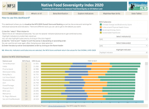
Explore the FSTI 2020 for US Native Land Dashboard
FSTI Components
The Food-System Transition Index is an aggregate measure from 20 complementary indicators to support sustainable and healthy food-systems on US native lands. The Index brings together key dimensions of sovereign indigenous food-systems, previously identified from native food scholars and practitioners’ definitions. This tool can be used for native food-systems assessments and planning, and lays out new potential for comprehensive and sustainable land and food-systems management. This important work was funded by the Indian Land Tenure Foundation.
To build the Index, 20 indicators were narrowed down to four distinct subscores:
- Sustainable Food
- Climate Change and Biodiversity
- Sovereign Energy
- Cultural and Physical Health
Each indicator was carefully selected for its capacity to:
- Measure a key dimension within the four subscores
- Contribute to telling the story of interconnected food-systems
Indicators had to measure clear phenomenon recognized as important for native food-systems, and had to be able to be aggregated at the reservation-level. Some measures did not previously exist and had to be entirely constructed to reflect the above rationale but within existing data constraints. The final Index follows the structure below:
Table of Contents
All FSTI Dashboards
Methods
To build the FSTI, data was collected and processed using GIS to harmonize it within reservation geographical boundaries, and further processed into excel and Tableau to build user-friendly visualizations. Boundary data used to define summary areas for all measures was obtained from the 2019 US Census Bureau’s TIGER/Line Shapefile for American Indian areas in the United States which includes both American Indians and Alaskan Natives, a total of 845 unique features or land areas including On-Off reservation. For the FSTI, we only use the AIANNHCE aggregation level, which combines both On-Off reservation areas into a final output of 695 native land areas. Depending on the data, we then use 3 levels of GIS data processing:
- Rez-County Overlap: For data that was aggregated at the county-level (ex: Diabetes Indicator). Data was extracted using the Rez-County Overlap Layer; a geographical tool engineered by the NLIS development team to match reservation boundaries with overlapping county-boundaries. Data was then aggregated at the AIAN level before being harmonized into the common FSTI processing format and normalized using min-max scaling in tableau. This data processing was carefully applied whenever other national reliable sources of data could not be found. Its trustworthiness is subject to data bias inherent to possible demographic clusters within county data (i.e. if a given county’s diabetes rate is brought down by a demographic cluster outside the reservation, it would inaccurately decrease the reservation’s average).
- AIAN raster and vector clipping: For raster-based (satellite) or vector-based (polygon) geographical data (ex: Solar Indicator), we clipped or selected the data using the AIAN 2019 tiger shapefile. Data was then harmonized into the common FSTI processing format and normalized using min-max scaling in tableau.
- Direct geographical matching: For data that was already aggregated at the AIAN geographical level (ex: Agricultural Sovereignty Indicator). Data was harmonized into the common FSTI processing format and normalized using min-max scaling in tableau.
Data was not always present at all the 695 geographies. Depending on the datasets, it ranges from 75 to 695 native land areas per indicator. In general, satellite-based datasets yielded 695 geographies when others were limited by the number of observations included in the original datasets. See table below for indicators and datasets details.
Building the FSTI Dashboard
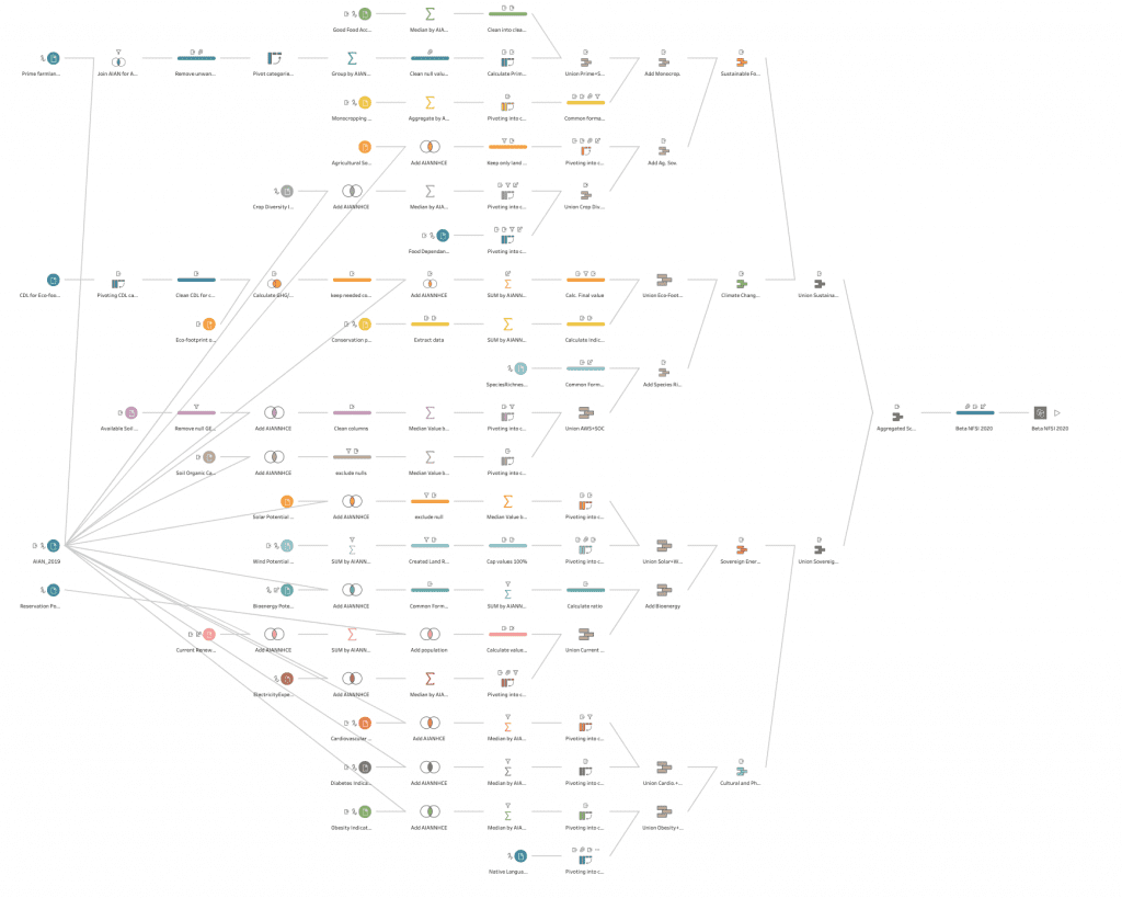
Each processed indicator was imported into Tableau Prep for cleaning and formatting into a common typology to allow easy reading and processing into Tableau analytics software. Once in Tableau, the data was normalized using min-max linear scaling multiplied by 100 to render an easily understandable average score. See figure of FSTI Tableau Flow below
FSTI limitations: fitting squares in circles
We have developed an Index on available and ethically safe data, and we present these indicators as a roadmap for further investigations to be carried on by tribes and tribal members to further develop this index so that it can mirror the type of Food-System that makes sense in each tribal context.
The FSTI 2020 does not aim at being comprehensive, it only delivers a useful tool from widely available public data to help users monitor and evaluate native food-systems and support their transitions towards healthier, stronger and more resilient models.
Here are some of the main limitations identified in the FSTI 2020:
- The FSTI 2020 only looks at macro-level food-systems. This is national-level data aimed at providing tribes with leverage to solve inequalities in agricultural opportunities. The result is a composite index from selected indicators built with existing datasets. Composite indices allow for meaningful comparison between recognized native lands. Indices remain however very linear ways to express the multi-dimensionality present in native food-systems. We are very aware of these limitations and are looking forward to think about other ways to produce and present data
- While we have accounted for the variation in data types by applying a linear scaling normalization, the final calibration of the Index is limited by indicators’ differential weights inherent to their variation in included geographies. Null values for missing geographies were ignored in the calculation of the final index, which gives unequal score weight to different native lands. This could only be fixed by using only datasets that would include the same number of geographies, which is not currently possible given the limited access to data. The purpose of the FSTI 2020 at this point is to strive for the best accuracy given existing limitations while providing room for enriching the debate around food-systems data
- Key components of Native Food Systems remain invisible in the FSTI 2020 as access to and use of that type of data is controversial and contains sensitive information that should be only processed by individual tribes. For instance, we know that the local harvesting of traditional food is very important to indigenous food-systems. However, even if there existed a database of harvesting sites, it would present ethical challenges as it holds spiritual values that need to be addressed by relevant local decision-makers. So many of the cultural indicators of food recognized as significant in the literature (ex: Woodley, et. al. 2009) could not be included for the same reasons. These limitations highlight the need for native nations to develop tools to handle sensitive data in a way that can serve their local food-systems planning while protecting their privacy and data sovereignty
Exploring Native concepts of Food Sovereignty
The 2002 declaration of Atitlán gathered 28 nations around what is known as the Indigenous Peoples’ Consultation on the Right to Food. It preceded the more cited Nyéléni declaration in affirming that “Food Sovereignty is the right of Peoples to define their own policies and strategies for the sustainable production, distribution, and consumption of food, with respect for their own cultures and their own systems of managing natural resources and rural areas, and is considered to be a precondition for Food Security”.
However, it also sets the specificities of indigenous food sovereignty around common challenges for land control, political determination and the right to redefine food within much broader social-cultural considerations. It strongly states that ” the denial of the Right to Food for Indigenous Peoples not only denies us our physical survival, but also denies us our social organization, our cultures, traditions, languages, spirituality, sovereignty, and total identity; it is a denial of our collective indigenous existence”, follows up by clear demands; the redistribution of world land base, sovereign management of land-tenure, equitable participation in global food decision-making, the enforcement of rights for nature and the legal protection and recognition of indigenous knowledge and worldviews.
These demands are nested in the political economy of colonial history and its main expressions: the enduring oppression of native lands and peoples to benefit the global extractive capitalist economy justified by mostly White Christian Patriarchal ideals.
These arguments are consistent throughout the definitions of Native Food Sovereignty (NFS) (Adamson, 2011; Calix De Dios et. al, 2014; Cidro et. al, 2015; Coté, 2016; Huambachano, 2018; Moeke-Pickering et.al, 2015; Whyte, 2016; Woodley et. al 2016).
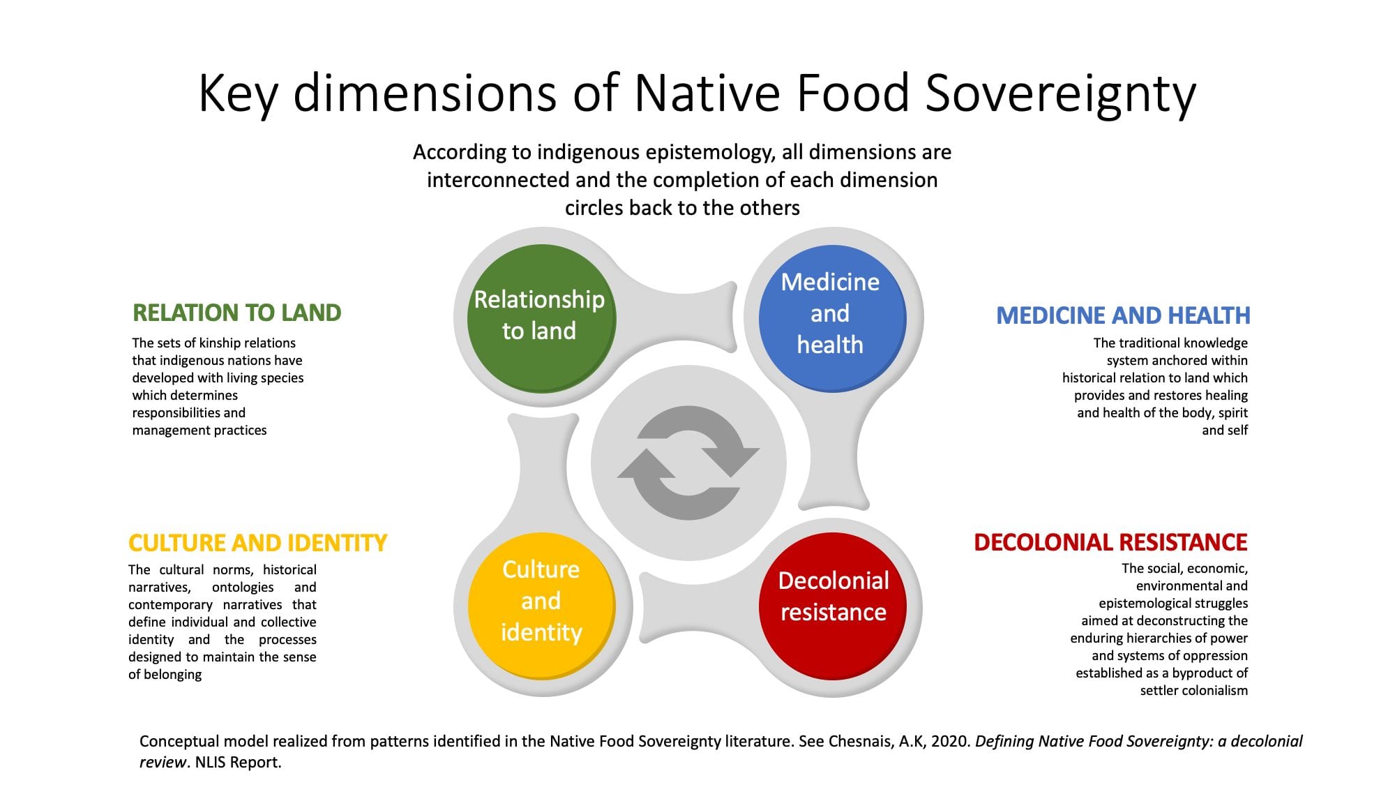
From a linear typology, NFS falls into four interrelated dimensions which informed our methodological framework (see figure below):
- Relation to Land
- Medicine and Health
- Decolonial Resistance
- Culture and Identity
Beyond embodying the enduring colonial oppression of native land, the particularities of Native Food-Sovereignty also carry a potential to define alternative models for native lands. These models do not just deal with food or land justice, but with its connection to us as a species. By proposing ways to explain and conceptualize food as a social, environmental, cultural and spiritual connection, the concept of Native Food Sovereignty gives us keys to design a truly just ecological transition for native land and beyond. This Index is our humble contribution to support that transition. While it remains constrained by the linearity of existing and the lack of relevant data, it invites us to think differently about food and food-systems and to find further ways to mold squares into circles.
Special thanks to contributors
The Index was a team effort developed by the Native Land Advocacy Project under 501(c)(3) Village Earth. However, the colossal work behind this Index could not have successfully been carried without the contribution of these amazing people:
Firstly a huge thanks to Jonathan Drummey, Tableau Zen Master who donated his time to provide key technical support on how to best visualize the data behind the Index.
Secondly, we would like to thank Jan Burck who leads the Climate Change Performance Index, for precious advices early on in this project on the best way to approach and build a solid Index.
We would also like to thank Joseph Poore, Ph.D from the University of Oxford, UK, for his advices and agreeing to share his amazing environmental footprint dataset prized in peer-reviewed journals, which allowed us to calculate the Eco-footprint of Agriculture production for US Native Land.
A special thanks to Keith Smith, Ph.D and Sophie McKee, Ph.D, for their statistical advices.
Finally, thanks to all the native scholars and practitioners who laid out the knowledge system which inspired this Index. We hope that this work will serve your respective goals to support sovereign food-systems on your lands.
Stay tuned!
The FSTI uses key indicators normalized for the final ranking. However, each of these indicators deserves an individual dashboard to explain their use, elaborate on their processing methods and release in their original units for best use for local land planning. The next step for us is to continue developing this resource so that individual dashboards can be used to support IRMPs and ARMPs planning. We also aim at testing hypotheses that further explain the status of food-systems on native lands from current and historical land policies.
References
Adamson, J. (2011). Medicine Food: Critical Environmental Justice Studies, Native North American Literature, and the Movement for Food Sovereignty. Environmental Justice, 4(4), 213–219. https://doi.org/10.1089/env.2010.0035
Huambachano, M. (2018). Enacting food sovereignty in Aotearoa New Zealand and Peru: revitalizing Indigenous knowledge, food practices and ecological philosophies. Agroecology and Sustainable Food Systems, 42(9), 1003–1028. https://doi.org/10.1080/21683565.2018.1468380
Calix de Dios, H., Putnam, H., Alvarado Dzul, S., Godek, W., Kissmann, S., Pierre, J. L., & Gliessman, S. (2014). The challenges of measuring food security and sovereignty in the Yucatán Peninsula. Development in Practice, 24(2), 199–215. https://doi.org/10.1080/09614524.2014.884540
Cidro, J., Adekunle, B., Peters, E., & Martens, T. (2015). Beyond food security: Understanding access to cultural food for urban indigenous people in Winnipeg as Indigenous food sovereignty. Canadian Journal of Urban Research, 24(1), 24–43.
Coté, C. (2016). “Indigenizing” Food Sovereignty. Revitalizing Indigenous Food Practices and Ecological Knowledges in Canada and the United States. Humanities, 5(3), 57. https://doi.org/10.3390/h5030057
First Nations Development Institute, & Balbas, S. (2006). Exploring the Vision of Native Food Sovereignty : An Institutional Framework. Report. Kane’ohe, Hawaii.
Indigenous Peoples’ Consultation on the Right to Food. (2002). Declaration of Atitlán, Guatemala. Indigenous Peoples’ Consultation on the Right to Food: A Global Consultation. Retrieved from http://www.treatycouncil.org/new_page_5241224.htm
Moeke-Pickering, T., Heitia, M., Heitia, S., Karapu, R., & Cote-Meek, S. (2015). Understanding Maori Food Security and Food Sovereignty Issues in Whakatane. MAI Journal – A New Zealand Journal of Indigenous Scholarship, 4(1), 30–42. Retrieved from http://www.journal.mai.ac.nz/sites/default/files/MAIJrnl_V4Iss1_Pickering.pdf
Whyte, K. P. (2016). Indigenous food sovereignty, renewal, and US settler colonialism. The Routledge Handbook of Food Ethics, (Pimberr 2009), 354–365. https://doi.org/10.4324/9781315745503
Woodley, E., Dookie, C., & Carmen, A. (2006). SARD Initiative logo Cultural indicators of Indigenous Peoples ’ food and agro-ecological systems the Right to Food and Food Sovereignty for Indigenous Peoples. Management, (September).

