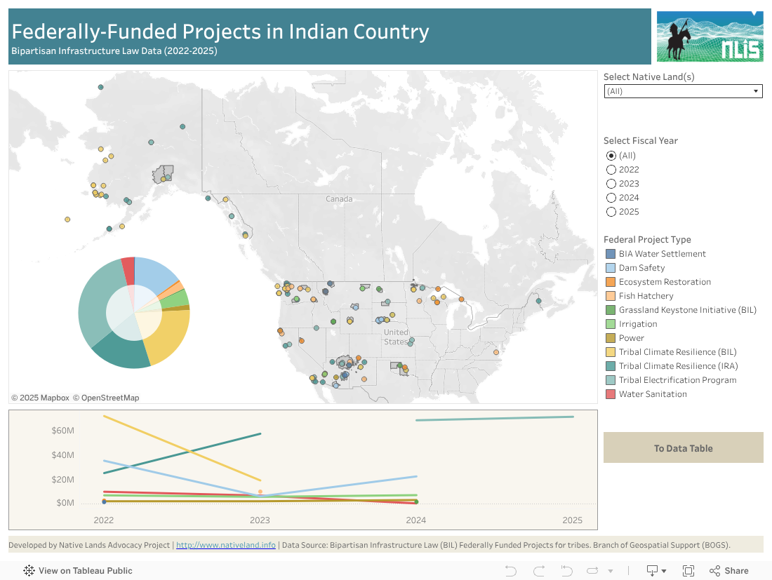
This data dashboard summarizes data about federally-funded projects within tribal boundaries from the Bipartisan Infrastructure Law and the Infrastructure Reduction Act. The visualization displays funds amounts and categories of federal project for all tribes for years 2022 through 2025 (it has not been modified for eventual funding freezes resulting from the current federal administration change).
The default setting shows funding for all tribes and all years included in the dataset. Data can be filtered for each tribal geography to identify funding allocated for all or each year represented. The bottom table shows the year to year evolution of funding across categories, which is useful to see patterns in government priorities for funding over years. Upon adding more years, it will allow users to visualise the impact of different administrations on funding for tribes. Hover over the pie chart for funding totals per category.
On November 15, 2021, President Biden signed the Bipartisan Infrastructure Law (BIL), which invested more than $13 billion directly into Tribal communities across the country and made Tribal communities eligible for billions more. These resources were supposed to go to other federal agencies to expand access to clean drinking water, high-speed internet, addressing environmental issues and more support for Native communities.
The U.S. Department of the Interior received a $466 million investment for the Bureau of Indian Affairs (BIA) for infrastructure projects and climate resilience initiatives as well as $2.5 billion to help the Department fulfil settlements of Indian water rights claims and deliver long-promised water resources to Tribes. The BIL also made Tribal communities eligible for additional Department of the Interior programs to support building resilience to wildland fire and drought, restoring ecosystems, enabling fish passage, and addressing legacy pollution from abandoned mine lands and orphan oil and gas wells.
On August 16, 2022, President Biden signed the Inflation Reduction Act that provided investments to address the climate crisis, lower costs for working families, and generate employment. Combined with the Bipartisan Infrastructure Law, these two initiatives represented the largest investments in climate resilience in the nation’s history and provided a once-in-a-generation opportunity for the work of the Interior Department.
Overall, the Department of the Interior was to receive $6.6 billion in direct funding through the Inflation Reduction Act. This funding was to help bolster bureaus and offices across the Interior Department to transition to a clean energy economy, advance key habitat restoration and land resilience projects, and secure environmental justice for historically disadvantaged communities. The total funding included a $385 million investment for the Bureau of Indian Affairs for climate resilience and adaptation and fish hatchery needs, as well as a new Tribal Electrification program.
Given the wave of federal funding freeze and federal employees firing that followed the recent administration change of January 2025, we do not know where these funds allocations, amounts, and management currently stand. Contact your grant representatives and associated federal agencies to demand accountability.
Information about federal funding and its distribution across the nation should be a basic service widely available to the general public as a token of the reasonable use of taxpayers’ money in service of the general good. The government of any proclaimed democratic nation-states exists to serve all citizens of the country and is allowed to make certain decisions about the allocation of present resources so long as it can justify reasonable use in service of the public good. Federal agencies, employees and elected officials are all public servants who owe their citizens a level of transparency that justifies the reasonable use of taxpayers’ money. That need for transparency and obligation of proving a reasonable use of resources is even more true in the case of tribal nations, whose nation-to-nation relationships with the federal government have formed the foundational agreements that continue to define the right of the United States to occupy its current land base. Understanding this basic but foundational principles should greatly inform federal relationships to tribes. And good relationships start with accurate information and good communication.
While this dashboard provides valuable insights into federal funding for tribes, there are several limitations and considerations to keep in mind. The Branch of Geospatial Support of the Bureau of Indian Affairs that delivered this data was created to assist Tribal governments and Indian Affairs to manage the cultural and natural resources of Indian Country by providing geographic information systems software, training, and technical support. While this service contains some useful layers and information and served to inform this dashboard, there are general significant issues with the data provided by BIA:
1) Data is often incomplete, or delivered in a format or scale that does not have tribal interests and priorities in mind.
2) The BIA’s consultation process with tribes for data collection, analysis and delivery remains cryptic, sporadic, and top-down. It happens at BIA’s pace and when they decide releasing data is a good time, which leaves tribes fully tributary to BIA’s timeline to receive information about their own lands.
Instead these research protocols and data/knowledge exchange protocols should be led by a deeper understanding of the aforementioned historic relationship where BIA as a public servant and trustee of native lands acts fully in service of tribes and their interests. BIA needs to question and consider that its self-appointed trustee also involves becoming a genuine data steward in a way that honors tribal needs for each tribal nation.
Feel free to check the BIA geodata portal here and contact BIA to demand more transparency and accountability: https://opendata-1-bia-geospatial.hub.arcgis.com/
We have updated our terminology from “raw data” to “source data” to better reflect the contextual nature and origins of the information we provide. This change acknowledges that all data is influenced by the context in which it is collected, and aims to promote a more inclusive and accurate understanding of the information presented. Click below to download the source data that we based our analysis from. For the NLAP enriched dataset for Native Lands, prefer the Data Tables Tab within the dashboard. You can easily download these by clicking on the bottom right corner for your preferred download format.