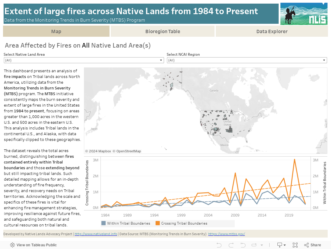
This data dashboard summarizes data from the Monitoring Trends in Burn Severity (MTBS) Dataset, which the USGS EROS and the United States Department of Agriculture Forest Service jointly implemented. It highlights the distribution and impact of wildfires on Native lands between 1984 and 2022. The dashboard features detailed maps and interactive elements, allowing users to explore fires that have occurred entirely within Native lands and fires that cross the boundaries of Native lands. By providing these insights, the dashboard aims to support resource management and planning for Native communities, offering a valuable tool to understand and address challenges related to wildfire and land use.
This dashboard includes data from the Monitoring Trends in Burn Severity (MTBS) program, which is jointly implemented by the USGS EROS and the United States Department of Agriculture Forest Service.
The MTBS program consistently maps the burn severity and extent of large fires across all lands of the United States, including the continental U.S., Alaska, Hawaii, and Puerto Rico. This includes fires of 1,000 acres or greater in the western United States and 500 acres or greater in the eastern United States. The dataset leverages Landsat and Sentinel-2 satellite imagery, providing high-resolution (30-meter) data on fire severity and extent.
Landsat is the primary data source for MTBS, offering a comprehensive historical record due to its extensive archive, the largest in the world. Sentinel-2 supplements this data, particularly in regions with persistent cloud cover, ensuring the availability of optimal imagery for mapping fires that would otherwise go unmapped. Both Landsat and Sentinel-2 data are analyzed using a standardized and consistent methodology, ensuring high-quality, reliable data products.
The MTBS dataset is crucial for a wide range of users, including national policy-makers, field management units, federal land cover mapping programs, and academic researchers. It aids in the monitoring and management of fire-affected areas, providing GIS-ready maps and data that are essential for understanding post-fire effects and implementing effective fire management strategies. The consistency and long-term availability of this data make it invaluable for both research and operational support projects, offering insights into fire severity and trends over significant geographic and temporal extents.
Boundary data used to define summary areas was obtained from the TIGER/Line Shapefile, 2022, Nation, U.S., American Indian/Alaska Native/Native Hawaiian Areas (AIANNH). This shapefile includes federally recognized American Indian reservations and off-reservation trust land areas, state-recognized American Indian reservations, Hawaiian home lands (HHLs), Alaska Native village statistical areas (ANVSAs), Oklahoma tribal statistical areas (OTSAs), tribal designated statistical areas (TDSAs), and state designated tribal statistical areas (SDTSAs). We filtered out features that did not contain any significant fires identified through the MTBS data to focus on relevant areas, ensuring an accurate representation of Native lands for the analysis.
Understanding the impact and extent of wildfires is crucial for managing and protecting Native lands. Wildfires significantly affect land use, resource availability, and the overall health of ecosystems. This dashboard provides essential insights into the distribution and severity of fires on Native lands from 1984 to 2022. By visualizing wildfire data, tribes can better plan and implement strategies for land management, disaster preparedness, and resource allocation.
The data displayed on this dashboard allows tribes to see which areas have been affected by wildfires, and how they intersect with tribal boundaries. This understanding is essential for developing effective fire management strategies, ensuring the safety and sustainability of Native communities, and mitigating future fire risks. Additionally, knowing the extent of fire-affected areas within each Native boundary provides a broad perspective on the land management challenges and needs of Native communities.
By integrating data from the Monitoring Trends in Burn Severity (MTBS) program, this dashboard offers a comprehensive view of wildfire impacts. The MTBS data, derived from Landsat and Sentinel-2 satellite imagery, provides detailed and consistent information on burn severity and extent. This combination of data is instrumental in promoting better planning and management of fire-affected areas on Native lands.
With climate change increasing the frequency and intensity of wildfires, this dashboard serves as a valuable tool for tribes to develop resilient land management practices. By understanding the historical and current impact of wildfires, tribes can implement strategies to mitigate fire risks, enhance resilience to climate change, and ensure the long-term sustainability of their lands and resources. This dashboard supports the goal of promoting effective fire management on Native lands, helping to secure the future of Native communities and their environments.
While this dashboard provides valuable insights into wildfire extent and severity on Native lands, there are several limitations and considerations to keep in mind:
Resolution of Data: The MTBS data is provided at a 30-meter resolution, which may not capture fine-scale variations within smaller areas or specific land parcels.
Temporal Coverage: The MTBS data covers the period from 1984 to 2022. Users should consider the temporal alignment when analyzing the data, as the frequency and intensity of wildfires can vary significantly over time. Additionally, the data may not capture very recent fires if they occurred after the last update.
Data Integration: Combining datasets from different sources, such as MTBS, Landsat, and Sentinel-2, may introduce inconsistencies due to differences in data collection methodologies, classification systems, and temporal resolutions. Care should be taken when interpreting integrated data.
Boundary Definitions: The boundary data for Native lands comes from the TIGER/Line Shapefile, 2022. This dataset includes various types of Native areas, but there might be discrepancies or updates in boundary definitions that are not reflected in this dataset. Moreover, the boundaries do not differentiate between fee and trust lands, which might affect the analysis.
Burn Severity Metrics: The burn severity metrics from MTBS are derived from satellite imagery and standardized methodologies. However, these metrics may not fully capture localized fire impacts or the ecological significance of burn severity due to variations in vegetation types and post-fire recovery processes.
Fire Extent Categorization: The categorization of fires by size (e.g., 1,000 acres or greater in the western U.S. and 500 acres or greater in the eastern U.S.) provides a general overview of significant fires but may exclude smaller fires that could still have important ecological or cultural impacts on Native lands.
Climate Change Impacts: While the dashboard provides insights into historical wildfire data, it does not include projections of future wildfire risk under different climate change scenarios. Users should consider external climate models and projections for a comprehensive understanding of future fire risks.
By considering these limitations and contextualizing the data within these constraints, users can make more informed decisions and interpretations regarding wildfire impacts on Native lands
We have updated our terminology from “raw data” to “source data” to better reflect the contextual nature and origins of the information we provide. This change acknowledges that all data is influenced by the context in which it is collected, and aims to promote a more inclusive and accurate understanding of the information presented.