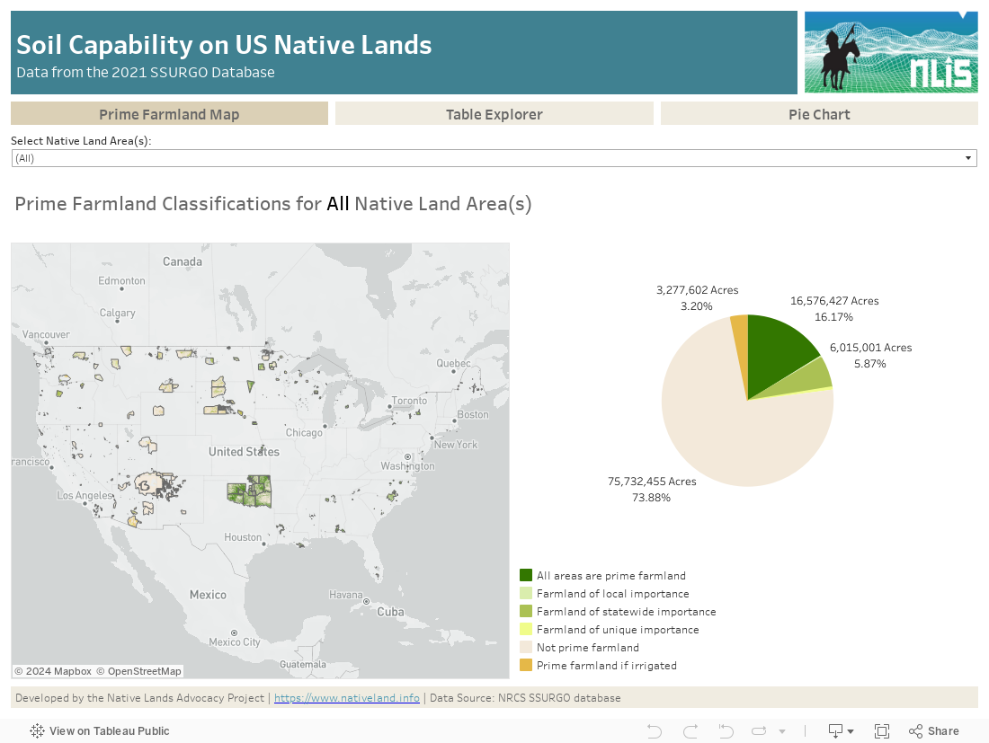
This data dashboard summarizes data from the 2021 Soil Survey for 552 unique Native land areas in the coterminous United States and can be filtered by one or more Native land areas.
According to the NRCS, “The SSURGO database provides the most detailed level of information and was designed primarily for farm and ranch, landowner/user, township, county, or parish natural resource planning and management. Using the soil attributes, this database serves as an excellent source for determining erodible areas and developing erosion control practices; reviewing site development proposals and land use potential; making land use assessments and chemical fate assessments; and identifying potential wetlands and sand and gravel aquifer areas.” The NRCS’s SSURGO data is used in numerous land valuation, carbon and hydrologic assessment models including the proprietary AcreValue™ valuation estimation tool, NRCS’s Rapid Carbon Assessment RaCa, the EPA’s Automated Geospatial Watershed Assessment (AGWA), and the Soil and Water Assessment Tool (SWAT), to name a few.
Using NRCS’s mapping standards, “soil maps in the SSURGO database are created using field methods. Surveyors observe soils along delineation boundaries and determine map unit composition by field traverses and transects. Aerial photographs are interpreted and used as the field map base. Maps are made at scales ranging from 1 :12,000 to 1 :63,360. Typically scales are 1 :15,840, 1 :20,000, or 1 :24,000. The maps, along with comprehensive descriptions, produce an attribute and spatial database for NRCS publications.”
The SSURGO data is available as either a raster (at 1 Om, 30m, and 90m resolutions) or vector layer, and the data for this dashboard is derived from the vector data. To facilitate analysis of the SSURGO data, the Native Lands Advocacy Project (NLAP) utilized the GSSURGO dataset, or “Gridded” SSURGO, which is a packaged data product developed by NRCS which utilizes the proprietary ESRI file geodatabase format and can be downloaded at the State or National level.
There is an extreme lack of data to assess the quality of soils on Native Lands in the United States. Most of the agriculture data collected by the United States Government is aggregated at the State and County levels, and because Native lands often overlap state and county boundaries, it makes it extremely difficult to count only for Native lands. This data and dashboard can be an invaluable tool for Tribes and Native peoples in general to assess the quality of their lands, prioritize areas for protection, development zoning, etc.
This dashboard aggregates data using the external boundaries of Native lands and Tribal statistical areas and does not differentiate between fee and trust lands within those boundaries.