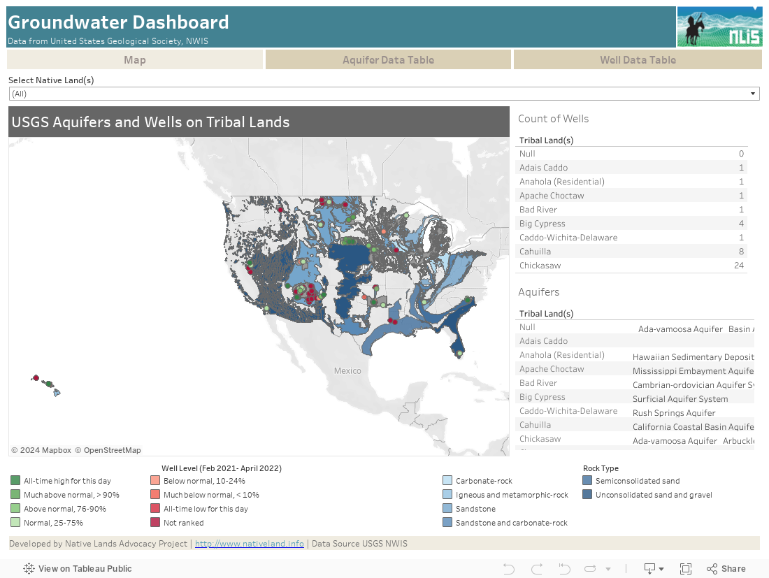
This data dashboard summarizes data from the National Ground-Water Monitoring Network, and the national datasets of principle aquifers and aquifers of alluvial and glacial origin for Native Lands in the United States. This data shows underlying water resources and data monitoring the condition of wells on Native Lands.
This dashboard includes data from the USGS’s National Ground-Water Monitoring Network (NGWMN), as well as Principle Aquifers, and Aquifers of alluvial and glacial origin in the USGS National Water Information System. The dataset that comprised the principle aquifer data was derived from the Ground Water Atlas of the United State which shows the areal extent of aquifers of the continental United States. The Principle Aquifer dataset was initially published as part of the National Atlas in 1998, and then revised in 2003. The dataset containing the aquifers of alluvial and glacial origin were published in 2002, and delineate the areal extent of the alluvial and glacial aquifers defined in The Ground Water Atlas of the United States. The data obtained from the National Ground-Water Monitoring Network aggregates data from local, State, and Federal organizations to provide information for planning, management, and the development of groundwater and monitoring groundwater aquifers throughout the United States. Data was obtained for Native Lands April 14, 2021 from the “Current Conditions for the Nation” data from USGS NWIS.
Aquifers with available data from the USGS include the Central Valley aquifers, Columbia Plateau aquifer, Denver Basin, Floridan, Great Basin Carbonate, Hawaiian, High Plains Aquifer, Lake Michigan Basin, Mississippi Embayment, North and South Carolina Atlantic Coastal Plain, Northern Atlantic Coastal, Plain, Pennsylvanian and Mississippian Aquifers of the Appalachian Plateaus, Upper Colorado River Basin, and the Williston and Powder River Basins. The aquifers of alluvial and glacial origin show aquifers of this origin from the southern-most line of glaciation – represented in the States of Maine, Vermont, New Hampshire, Connecticut, Massachusetts, Rhode Island, New Jersey, New York, Pennsylvania, Ohio, Indiana, Michigan, Wisconsin, Illinois, Minnesota, Iowa, Missouri, Kansas, Nebraska, South Dakota, North Dakota, and Montana. These data are important in considering the near-surface aquifers, while the map layer showing the aquifers of alluvial and glacial origin are good for considering water-bearing materials that are along water courses and glaciated regions. The two types of aquifers are important to consider in the risk and longevity of access to that water source.
Boundary data used to define summary areas was obtained from the 2021 US Census Bureau’s TIGER/Line Shapefile for American Indian areas in the United States which includes both American Indians and Alaskan Natives, a total of 845 unique features or land areas. From this we removed all features/areas that did not overlap with the existing aquifer and well data. There are 347 wells from National, State, and local sites included in the NGWMN that are on 99 Native Lands in the United States – this data is displayed on the dashboard. Additionally, there are 104 Native Lands that overlap the national data for aquifers of alluvial and glacial origin, and 376 Native Lands that overlap the national data for primary aquifers.
Water is an essential resource for the management of tribal lands and is a key consideration for land management planning. Without inventorying the water resources available on tribal lands, it will not be possible to make appropriate land use decisions. Water resources include both surface water and groundwater. Adequate water supplies are necessary for land management considerations, but also the quality of water is necessary to provide safe drinking water, safe habitat, for safe recreational use, and to maintain healthy plant communities. Using the data displayed, on this dashboard, tribes and tribal members can see the primary aquifers below tribal lands, and use this information to look at local reports on aquifer use and recharge. Additionally, if aquifers of alluvial and glacial origin are a primary source of water, it will be important to include the longevity of these sources as the climate changes. The well data is important in monitoring the wells located on tribal lands. The data displays the depth to groundwater from the surface in feet, and some data points can be compared using the most recent data to historic water levels (since 2009, when the monitoring network was established) to determine the overall condition of the water levels in that well.
The major limitation of this data is that it does not include monitored wells for all Native Lands that overlap with underlying aquifers – meaning there is an absence of data for status of these water resources. Additionally, the dataset containing the Aquifers shows the area of the aquifer that is shallowest of the principle aquifers, but these may not necessarily be the only areas where water can be drawn. The data used for this may not accurately show the extent of aquifers at the site level due to there being deeper layers of the aquifer not mapped here, or there being overlap between aquifers, or layers of low-permeability materials. The well data included integrates data from wells that are monitored periodically and wells that are monitored continuously – due to this the dates of well monitoring range from February 26, 2021 to January 31, 2022.